THE
BROAD
WAY
| A Pennsylvania Railroad Home Page
PRR INTERLOCKING
DIAGRAMS
|
LOGANSPORT TO
CHICAGO
| |||
|
THE
BROAD
WAY
| A Pennsylvania Railroad Home Page
PRR INTERLOCKING
DIAGRAMS
|
LOGANSPORT TO
CHICAGO
| |||
Milepost numbers are from PC Western Region Timetable #1, 1968-04-28. Distances are from Columbus.
The main line and Richmond Branch join, and the main line proceeds northwestward. Also see my hand-drawn map of Logansport.
An automatic interlocking protecting the crossing of the Panhandle main with the Wabash Toledo/Detroit--St. Louis main.
Major junction of the Panhandle main with the I&F Branch south to Indianapolis; the Effner Branch west to Effner and the TP&W; the South Bend Branch northward to its namesake city; and the Logansport Branch northeast to Columbia City (Fort Wayne main) and connection with the Wabash.
Parallel PRR and C&O are crossed by Erie main line and NYC Kenkakee Branch. Telegraph designation thought to be JD.
?Renamed JUDD at some point [when?]. [] Erie line pulled up soon after the formation of Conrail; PRR removed around 1982. [Jon Roma]
Crossing of the Monon Michigan City branch. Prior to 1940, the Chicago, Attica & Southern crossed as well. [Bob Poortinga]
The Erie is re-crossed.
Crossing of the EJ&E and the NYC Joliet Branch. The tower closed in 1994 [Jon Roma].
Crossing of the Panhandle main and the GTW Port Huron--Chicago main, as the latter road makes its circuitous approach into Chicago. By 1968, this interlocking was remotely controlled from HARTSDALE.
The original has a distinct stippling to the background in a square patch, on the left side of the map, from the vertical boundary line to and including the 1P in the horizontal dimension, and from "JCT" to just shy of "Chicago" in the vertical direction, probably indicating an edit of the map. Further, the following text is very light; I am uncertain if this is an erasure or an addition: "0", "2", and "12" to the left of the lever counts; "Xing Levers"; "6 Spare Levers"; "Yellow On / Red Off"; and "XL17" and "XL19" (and associated arrows) just west of the diamonds.
Crossing of the Panhandle main and the CI&L (Monon). By 1968, remotely controlled from HARTSDALE. Note this location is not far away from MAYNARD (and neither is the third point in the triangle, where GTW crosses the Monon), requiring close coordination among operators. [MDB, Jon Roma]
Remotely controlled via CTC panel from MAYNARD according to the latter's map. By 1968, BERNICE was remotely controlled from HARTSDALE.
Junction, northward, with the SC&S or "Bernice Cutoff". See the Chicago branches page.
Complicated crossing of the Panhandle main with the IHB and the C&WI; B&OCT is also involved in the interlocking.
(Szwajkart 1976, pp. 162-163)
Not far from DOLTON, the B&OCT passes to the west of the Panhandle and enters Barr Yard. Another location where close coordination was required (with DOLTON) lest a deadlock occur. The Panhandle turns slightly, to north-northwest.
Note that The IC is on an overhead bridge, yet IC is responsible for maintenance of the interlocking. Moreover, note the orientation of the tower with respect to the interlocking and the lack of low-numbered levers. The IC was raised and electrified ca. 1926 and, for some reason, IC retained ownership. The tower closed ca. 1986. [MDB, Jon Roma]
On the original map, the lower arm of 127/128 is indistinct near the mast. I cannot make out if a lower marker can light separately or not.
Here the Panhandle crosses the (electrified) Blue Island Branch of the IC. [MDB, Jon Roma] Street location: Union (just E of Halsted) and 121st.
On the original map, there are 2 very faint streets. One, with no name I can make out, starts just to the left of the point of the "north" arrow, proceeds through the switch above the "P" between the two main tracks, and proceeds to and through the "H" and "A" of "MECHANICAL". The second street is labeled "Halsted St." and runs from just above the westward main at the left end of the drawing, through the switch on that main, through the switches on the siding track, and ends half an inch above the "I" in "MACHINE". The blade of a distant signal, at diagonal, is in the middle of the street, just before the intersection. Moreover, there appears to be a very faint tail blade of a "north" arrow intersecting the "M" in "MACHINE". Notably, it is at a different angle than the north arrow presently on the map. Finally, the erasure of the word "Terminal" in "Chicago Terminal Division" is clearly seen.
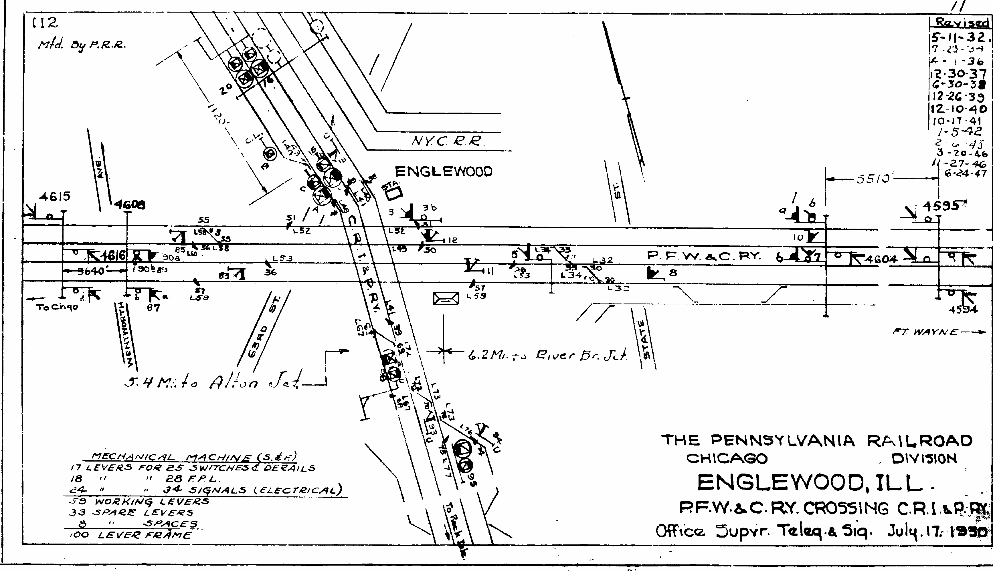
The Panhandle crosses the main line of the CRI&P, which is paralleling Vincennes Ave.(St.?) This is the same RI main line that will soon be crossing the Fort Wayne main at ENGLEWOOD. A RI station, not shown on the map, is on the (RR-)south side of the Pennsy, before the crossing.
Street location: Vincennes at Beverly and 103rd (1200W, 10300S) From here, the Beverly St. closely parallels the Panhandle main line, which now (1998) sports new houses.
On the original map, the RI signal at the lower right, closer to the 2690', is indistinct at its top. Presumably it would be depicted with a pointed blade. I have elected to keep the image as is.
Beverly Hills (also called ROCK ISLAND CROSSING) is the crossing of the CRI&P Suburban Line. Tower "A" at this location controls the crossing. A mere 1300 feet (400 m) farther, the Panhandle crosses a B&OCT branch (gone in 1998). This crossing is controlled by Tower "B".
Though one might otherwise think the Panhandle line to be a continous Main Line from Pennsylvania Station Pittsburgh to Union Station Chicago, technically, the main line ends here, and the line continues RR-west as the Beverly Jct. --- Western Ave. Secondary Track. I would love to hear why this was done at all, but I presume it was to avoid interlocking the multitudinous, complicated junctions north (RR-west) of 59th St. Yard. However, it is truly incomprehensible to me why the junction point was here, and why main line status and upgraded signalling were never extended through just one more junction and to the southern end of 59th St. Yard.
(Szwajkart 1976, pp. 114-115)
Street location: Beverly/Hermitage (W of Ashland) at 91st. (1700W, 9300S) [MDB, Jon Roma]
The Panhandle forms the eastern border of the Dan Ryan Woods, then turns due north between along Leavitt (between Damien 2000W and Western 2400W). Near 80th Pl., the B&OCT -- one of the lines emanating from the west side of Barr Yard -- comes alongside the Panhandle. These two will travel together for quite a way.
The Panhandle and parallel B&OCT cross the WAB and C&O-BRC. The location is just south of 75th St. Also known as FOREST HILL, 75TH STREET, and PANHANDLE CROSSING. The tower was a fascinating mechanical interlocking, closed in Nov. 1997, razed Oct. 1998. [MDB, Jon Roma] Street location: between Damien and Western at 75th.
(Szwajkart 1976, pp. 110-111)
The Panhandle and B&OCT trade places: from here north (RR-west), the Panhandle is on the west side, the B&OCT on the east. Also, GTW/IHB cross west to east (?at grade; ?grade separated). The CJ, a NYC affiliate, serving the area of the [former, and famous[ly smelly]] Chicago Stock Yards, joins in on the east side, and a largish yard is here from 47th to 39th Sts.
Proceeding from here, the parallel lines of PRR, B&OCT, and CJ turn northwest, cross to the west side of Western Ave./Western Blvd., and then turn north again.
The Panhandle, B&OCT, and CJ cross the Alton (GM&O). This antiquated plant and operating style, wherein all trains are required to stop and are given a simple semaphore signal to proceed or not to proceed, remains operational to this day (1998), even despite Amtrak trains on the Alton. The Western Region timetable does not list this as an interlocking, as it is a noninterlocked crossing at grade.
Street location: Campbell (W of Western) at 37th; easiest access from 36th.
(Szwajkart 1976, p. 102-103)
The same three railroads (Panhandle, B&OCT, CJ) cross parallel ATSF and IC main lines. The Western Region timetable lists this as an interlocking, with an interlocking station. The Drainage Canal Drawbridge is given a separate listing in the employee timetable but is not an interlocking. Note the dry former canal bed. Note also how the drawbridges are normally unattended.
Street location: W of Western, at level of 32nd; access presently very difficult; operators access tower via nearby industry.
(Szwajkart 1976, pp. 100-101)
Crossing with the Illinois Northern (part of ?ATSF).
Street location: just W of Western at 26th.
Connection (?crossing) with the BN (CB&Q) main line to Union Station. Street location: just W of Western at 18th.
Crossing with the C&NW and B&OCT. (The latter, east of here, creates the St. Charles Air Line connection to the IC - the only piece of prototype railroad that, in my humble estimation, approaches the appearance (in terms of curvature and close clearances) of model railroad track; and which, despite this, manages to host Superliner cars.)
Also shown on this map are the C&NW RR switchtender location TAYLOR ST. and the B&OCT RR switchtender location ROCKWELL ST. on the latter road's Forest Park Branch.
Here the Panhandle turns about 2 blocks to the west, then continues north. Nearing WESTERN AVENUE, the Panhandle turns due east. I've not found a source yet indicating the exact location of the division post, but it may be at the western limits of that interlocking.
The Panhandle has turned, paralleling the Chicago & North Western. The Milwaukee Road crosses the latter road to join the Panhandle for the final run into the north side of Union Station. On the MILW, the tower is known as A-2. The timetable direction changes from west to east at the western limits of WESTERN AVE.
(Szwajkart 1976, pp. 90-91. In the same reference, also see pp. 92-93, though no interlocking exists on the PRR at that point, only on the parallel C&NW)
This tower controls the northern appraoch to Chicago Union Station.
| ATSF | Atchison, Topeka & Santa Fe |
|---|---|
| B&OCT | Baltimore & Ohio Chicago Terminal |
| BRC | Belt Railway of Chicago |
| C&A | Chicago & Alton; later Alton, later merged into GM&O |
| C&E | Chicago & Erie |
| C&O | Chesapeake & Ohio |
| C&WI | Chicago & Western Indiana |
| CI&L | Chicago, Indianapolis & Louisville, "the Monon" |
| CJ | Chicago Junction, = CR&I |
| CNW | Chicago & North Western |
| CR&I | Chicago River & Indiana |
| CRI&P | Chicago, Rock Island & Pacific |
| EJ&E | Elgin, Joliet & Eastern |
| GM&O | Gulf, Mobile & Ohio |
| GTW | Grand Trunk Western |
| IC | Illinois Central |
| IHB | Indiana Harbor Belt |
| IN | Illinois Northern (part of ?ATSF) |
| MILW | Chicago, Milwaukee, St. Paul & Pacific, "the Milwaukee Road" |
| RI | "Rock Island", CRI&P |
| WAB | Wabash |
Mark D. Bej